Great Blue Hole Belize: Scenic Flight & Photos

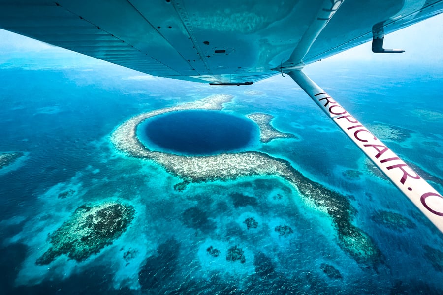
The Great Blue Hole in Belize is probably one of the most famous travel photos ever. It’s also the biggest underwater sinkhole in the world, and it looks even more amazing if you see it in person! Touring the Blue Hole is one of the top ‘bucket list’ things to do in Central America. You can enjoy a scenic flight over the reef in a small plane or helicopter, and take photos of it from above, or hop on a boat and go scuba diving inside the sinkhole itself. I got a chance to fly over the Great Blue Hole in a little prop plane recently, and it was an amazing experience! We circled the Blue Hole several times at low altitude to see what it looks like up close, and then flew over some other sights in the Caribbean Sea. This travel blog will share my experience with the Blue Hole Belize flight, which company to use, flight costs and safety thoughts, and everything else you need to know before you go. Then, I’ll share some fun facts about this natural wonder in the Caribbean! What Is The Great Blue Hole? The Great Blue Hole is an underwater sinkhole. It’s believed to have been a cave at some point in time when the water levels were lower, but then it became submerged as the water levels rose. Think of the Blue Hole kind of like the cenotes in Central America, except this one is underwater instead of on land, and it’s filled with seawater instead of fresh water.  Where Is The Great Blue Hole In Belize? The Great Blue Hole is located in the Caribbean Sea. It’s part of the Central American country of Belize, which is a little country sandwiched between Mexico and Guatemala. The Blue Hole is part of the Belize Barrier Reef, which is actually the second largest coral reef system in the world, after the Great Barrier Reef in Australia. More specifically, the Blue Hole is located in a marine atoll called Lighthouse Reef, about 75 kilometers (45 miles) off shore from Belize City, so you need a boat, plane, or helicopter to get there. Blue Hole Belize Flight: What To Expect Scenic flights over the Blue Hole are available every day of the week in Belize, departing from either Belize City Municipal, Caye Caulker, or San Pedro. They’re currently offered by three main companies: Tropic Air, Maya Island Air, or Astrum Helicopters. My flight with Tropic Air began with the quickest and easiest check-in process ever, and then I was handed a very unique and fancy plastic boarding pass with some fun facts about the Great Blue Hole printed on it. I was kind of wishing I could keep this as a souvenir from my flight! After a short wait in the lobby, one of the pilots came over and gave me a quick rundown of what sights we would see in Belize and where we would be going on a map, and then we headed out to the tarmac for our flight. A very unique boarding pass for my Great Blue Hole Belize flight If this is your first time flying in a puddle jumper plane, you’re in for a very exciting ride. This was the tiniest prop plane I’ve ever seen! It was only a 4-seater, with two pilot seats in the front and two passenger seats in the back. I later found out that Tropic Air also has 11-seater planes for some of their tours, so it probably just depends how many people are in your group. As it turns out, I was by myself this time. I booked my flight as a shared tour, but I ended up being the only passenger there, so I got to enjoy a private tour instead, while a student pilot practiced the route with help from a more experienced second pilot. The smallest plane I’ve ever seen! Preparing for takeoff I have to say, lifting off the ground in a plane this small is a bit scary at first, but you forget about that once you’re in the air. Right away, we had amazing views of Belize City, followed by some small islands, mangroves, coral reefs, and the turquoise blue water of the Caribbean Sea. I’ve been able to see these kinds of sights from above many times with today’s drones, so it wasn’t completely new to me, but it’s still different being up there yourself and seeing it with your own eyes. After about 20 minutes of flying over the ocean, we reached the Great Blue Hole of Belize. It’s so impressive in person! My photos don’t really do it justice at all. Every seat in the plane had great views out the window. The pilot flew down to a low altitude and circled the Blue Hole several times, so I could see it up close and take pictures. It was perfect. After leaving the Great Blue Hole, we passed a rusty old shipwreck stranded on the reef, which was another nice photo opportunity. Our total flight time was only about 1 hour from takeoff to landing, but it didn’t feel too rushed at all. We got to see a lot of things during the flight, and I was able to take tons of pictures. My only gripe is the windows on the plane, which were too thick, scratched, and dirty for serious photo work. I asked beforehand about doing a doors-off flight (or at least opening a small window), but neither of the two prop plane companies I asked were able to do that. I didn’t check with Astrum Helicopters, but that might be an option with them. Maybe I’m being too picky. I just think something as fantastic as the Blue Hole really calls for opening a door or window so you can take the best pictures possible. Overall, though, it wasn’t a huge deal. I was still able to get some decent pictures, and the flight itself was amazing! Tropic Air vs

Great Blue Hole Belize: Scenic Flight & Photos Read More »

Acatenango Volcano Hike: Volcan De Fuego Guatemala

The Acatenango volcano hike is a bucket list trek in Antigua, Guatemala where you can camp on top of a mountain and see frequent live eruptions from a nearby volcano called the ‘Volcan De Fuego’ (which means Volcano of Fire)! You can do the Acatenango hike with a guided group in 1, 2, or 3 days, although the most common way to do it is a 2 day 1 night trek, which usually gives you enough time to see eruptions from Volcán De Fuego during the daytime and also the glowing red fireworks at night. Is it worth it? Absolutely! Where else in the world can you camp this close to an actively erupting volcano and take pictures at a safe distance? Not many places. The Volcan De Fuego puts on a spectacular show, with small eruptions every 15-30 minutes! Guided tour prices are very reasonable, and one of the great things about trekking Acatenango is that it’s very safe. However, this is still a high elevation hike with lots of challenge, distance, and elevation gain, plus you’ll have to cope with a bit of cold weather and possibly some degree of altitude sickness. This travel blog will explain how to do the Acatenango volcano hike, what to bring, best time to hike, which trekking guides and tour companies to use, and everything else you need to know before you go! Where To Stay In Antigua Acatenango Quick Facts* *These stats are for hiking to Acatenango summit and don’t include the extra/optional hike to Volcan De Fuego  Volcán De Fuego views from Acatenango Best Acatenango Volcano Tours GetYourGuide has Acatenango trekking tours for 1, 2, or 3 days, where you can camp near the Guatemala volcano and watch the eruptions, plus some of them include the optional hike to Volcan De Fuego to see the eruptions even closer. These tours are run by Old Town Outfitters in Antigua, Guatemala, and they have hundreds of positive Google reviews from happy customers of all nationalities. Other high rated tour companies for this hike include Wicho & Charlie’s, Soy Tours, Tropicana, OX Expeditions, and Tours & Activities SA. We’ve used GetYourGuide for lots of tours and activities around the world, and they’re great. Highly recommended! Where Is Acatenango & Volcan De Fuego? The Acatenango volcano is located west of Guatemala City, overlooking the town of Antigua. Most people base themselves in Antigua for this hike, since it has plenty of hotels and restaurants, and it’s only about 30 kilometers from the volcano (a 1.5 hour drive).  About Volcan De Fuego The Volcanes De Fuego is the star of this hike. While Acatenango is an inactive volcano, Fuego is highly active and it sits right across from Acatenango, far enough to be safe for camping, but close enough to give you amazing views of the eruptions. The Fuego volcano usually erupts once every 15 to 30 minutes, although it can sometimes do shorter or longer intervals. During my 3 day hike, it was erupting every 10 minutes on the first day. By the second day it had slowed down to every 30 minutes, and on the third day it was only erupting every hour, but each eruption was enormous. The intervals are not completely predictable, but if you spend a couple days on the mountain summit then you can almost be certain that you’ll get to witness multiple eruptions. Volcanes De Fuego normally erupts every 15-30 minutes Watching the eruptions from Acatenango base camp Acatenango Sample Itinerary Here’s a sample itinerary for a 2 day, 1 night Acatenango volcano hike: Of course, this is just a sample itinerary and your trek may not go exactly like this, but the 2 day treks normally tend to follow this general pattern.   Acatenango Trekking: What To Expect • Starting The Acatenango Volcano Hike The Acatenango trek starts with a steep uphill walk on a dirt path that takes you through Guatemalan farmlands and jungle. The grade is tough and unrelenting from the beginning. In fact, this first section is actually one of the hardest parts of the hike! The main path is never dangerous in terms of cliffs or drop-offs, it’s just a grueling workout. For most of the hike, you’ll also be hot and sweaty, and trying to shed every layer possible. Once you reach the jungle, the grade is a bit more manageable and you have some nicer views, plus more shade from the sun. You’ll pass a couple of makeshift drink stands along the way, where you can buy snacks and drinks if you think you might need more. • Acatenango Base Camp After awhile, you’ll reach Acatenango base camp and witness your first eruptions from Volcan De Fuego in the distance! You’ll most likely hear it before you see it. The size and amenities of your camp will depend on which trekking company you book with, and some are higher quality than others. A warm campfire is a given. Some companies even have little cabins, while others have tents. This doesn’t make a huge difference since most people will only be staying one night anyway, and if we’re being honest you probably won’t get an amazing sleep regardless of how nice your camp is. The important thing about base camp is that it has a direct view of the eruptions at Fuego — you feel like you can reach out and touch it! • Volcan De Fuego Saddle Hike After you reach Acatenango base camp, your trekking company will usually give you an option to hike over to Volcan De Fuego and see the eruptions up close! This was the highlight of the whole trip for me. Roughly half of the trekkers in our group went on this expedition, and we were all so glad we did. For this journey, you will temporarily leave the comfort of your beloved camp and hike down the steep and sandy slopes of Acatenango, cross the saddle between these two Guatemala volcanoes, and then climb up the side of

Acatenango Volcano Hike: Volcan De Fuego Guatemala Read More »

Dhigurah Island Travel Guide For Maldives

Dhigurah island is probably the most beautiful island you’ve never heard of in the Maldives. It’s a local island without the fancy overwater resorts that are famous in Maldives, but instead it has a long and wonderful white sand beach. If you’re wanting to see the Maldives on a budget, this is one of the best places to do it. Dhigurah has all of the amazing tropical scenery you’d expect from the Maldives, plus family-owned hotels that are as low as $70 USD per night! We recently visited two local islands in the Maldives, Dhigurah and Fulidhoo, and couldn’t be happier with our choice. This travel guide will explain how to get to Dhigurah island, what to do there, where to stay, and everything else you need to know before you go! How To Get To Dhigurah Island There’s no airport in Dhigurah, so you first have to fly to the capital of the Maldives at Male International Airport (MLE), which is about 100 kilometers (60 miles) from Dhigurah. From Male, you can take a speedboat or ferry directly to Dhigurah, or you can take a seaplane or domestic flight to one of the nearby islands and then get a boat the rest of the way. Dhigurah island • By Public Speedboat The main way to get to Dhigurah is by public speedboat. There are morning and afternoon departures every day from Male city and the airport. The speedboat journey to Dhigurah takes 2 hours and costs about $50 USD per person one way. Kids above 3 years old pay full price. The boat ride usually isn’t too bumpy (depending on weather), and they have a toilet and plenty of room for storing luggage. The boats are new and the seats are comfortable. They also give you free bottled water. The boats from Male to Dhigurah depart at 11 AM (Friday 10 AM) and 4:30 PM. The return boats from Dhigurah to Male depart at 6:30 AM and 1:30 PM (Friday 1:45 PM). There’s a brief stop in Dhangethi island on the way to Dhigurah. However, keep in mind there are multiple speedboat companies operating this route and the timetable seems to change occasionally, so I’d double check the timetable with your hotel in Dhigurah before you go. You can ask your hotel in Dhigurah to book the speedboat for you, and then pay for it with your room bill when you arrive. That’s what we did, and paying by credit card spared us from having to carry lots of cash everywhere.  • By Private Speedboat A private speedboat charter will be a lot more expensive than the public speedboats, but it may be more convenient in cases where you want to save time and need a direct connection to Dhigurah from one of the other islands in the Maldives. You should be able to arrange this with your hotel in Dhigurah island. Lazy palm tree • By Domestic Plane One of the easiest ways to get to Dhigurah is by taking a 20 minute domestic flight with Villa Air / FlyMe from Male to the airport in nearby Maamigili island (VAM), followed by a 5 minute taxi ride to the harbor and then a 20 minute speedboat ride to Dhigurah. This route usually has 3 or 4 flights per day. One way ticket prices start at $170 USD for adults and $85 for kids under 12 years old, while kids under 2 fly free. The speedboat transfer is normally included in the price. In rare cases where the waves are too rough for a normal boat crossing, then this may be your only option of getting to Dhigurah.  • By Seaplane A seaplane ride is one of the most scenic and fun ways to get to Dhigurah, but also the most expensive. Ticket prices start at $250 USD per person, and the journey involves a 30 minute flight to the Lux Resort in the South Ari Atoll, followed by a 10 minute speedboat ride to Dhigurah. There isn’t a fixed schedule for the seaplane flights, so you’ll have to arrange it with your hotel in advance, and hopefully you can share the flight with other passengers going in the same direction.  • By Public Ferry Last, but not least, you can take the public ferry from Male to Dhigurah. This is the slowest option, but it’s also the cheapest. The ferry ride to Dhigurah takes about 6 or 7 hours and costs $8 USD for a one way ticket. This route is operated by MTCC several days per week, with morning and evening departures. You can confirm the current timetable with MTCC or with your hotel in Dhigurah, and they should be able to help you buy tickets as well. The beach is never crowded here Drone pic of Dhigurah island How To Get Around Dhigurah Island Once you arrive in Dhigurah, the next step is getting around the island. Thankfully, the whole island is small enough to be walkable. You can get everywhere on foot! From end to end, Dhigurah is only 4 kilometers long (3 miles), and the width of the island is only about 100 to 200 meters. This is one of the things we really liked about Dhigurah island, because it’s so convenient and you don’t have to pay for transport. However, the hotels do have bicycles you can rent for a half day or full day if you’d like.  Best Things To Do In Dhigurah Island • North West Beach / Bikini Beach The main beach in Dhigurah is called North West Beach and it spans the entire west side of the island. This is the island’s designated ‘bikini beach’ where tourists are welcome to wear swimsuits and go suntanning. It’s a beautiful beach with palm trees, lots of little hermit crabs, and not too many people. The water is calm enough for kids to swim. If the sky is clear, you can also watch the sunset on the beach. For snorkeling, there’s a spot near the

Dhigurah Island Travel Guide For Maldives Read More »

Best Sunrise Spot In Thailand

The Samet Nangshe viewpoint in Thailand is one of the most beautiful places I’ve ever seen in my travels. It’s also fairly easy to get there by driving from the tourist island of Phuket. This viewpoint overlooks the spectacular Phang Nga Bay, a Thai national park with dozens of small islands. The sunrise at Samet Nangshe is especially nice because the sun rises directly over the bay! You can visit Samet Nangshe viewpoint on a day trip from Phuket and go back in the same day, or you can stay a night or two at the Samet Nangshe Boutique hotel, which has a pool and rooms that overlook the same wonderful scenery. This travel guide will explain how to get to Samet Nangshe viewpoint with or without a tour, where to stay, and everything else you need to know before you go! The incredible sunrise at Samet Nangshe viewpoint Samet Nangshe Viewpoint: What To Expect There are two different places in Phang Nga province where you can enjoy the stunning view of the bay: you can go to Samet Nangshe viewpoint, or you can see a nearly identical view from the Samet Nangshe Boutique hotel, which has multiple vantage points at different levels on the hill. Most of the pictures in this blog post were taken at the boutique hotel, but the view is essentially the same in either place. It’s a marvelous view, with lots of small islands in the bay, and one big karst island that towers above the rest. It looks like a fairytale landscape. Drones are allowed at the viewpoint, and you can take some pretty amazing photos of the bay from above. They also allow drones at the hotel, but they asked us to do it at the parking lot so we wouldn’t disturb anyone at the hotel, which is fair and to be expected. An aerial view of Phang Nga Bay in Thailand Samet Nangshe Viewpoint When you first arrive at Samet Nangshe and park your vehicle, there’s a bit of climbing to do. The viewpoint is on top of a steep 800 meter hill, and they have a 4×4 truck shuttle to take you up there, or you can hike up there yourself in about 15-20 minutes if you’re fit and you want to save a little bit of money. It’s not possible to take your own vehicle to the top, so these are your two choices. Personally, I’d recommend the shuttle, especially if you’re coming in the dark for sunrise. The hilltop has a cafe and some touristy swings and bird nests for taking Instagram photos, which will be fun for kids and families. There are little primitive bungalows you can rent for 700 Baht (~$20 USD) per night, or you can even camp up there in a tent for 200 Baht. I’m sure the prices will go up as this place becomes more and more popular! Jurassic Park vibes If you go to the Samet Nangshe Boutique hotel, there’s a similar setup for reaching the viewpoint: a shuttle can take you up there, or you can hike it yourself. There are multiple vantage points at the hotel, but the very best one in our experience was the Bay View Cafe, which is the highest point at the hotel. After the sunrise, you can buy food or drinks at the cafe while enjoying the scenery. It’s an amazing view, and we felt like we could’ve stayed there a week just relaxing and taking pictures. Somewhere out there in the bay is Thailand’s famous James Bond Island, although you can’t quite see it from the viewpoint. It’s easy to go there on a day trip from Samet Nangshe, and if you stay at the boutique hotel they can arrange that for you. Another aerial pic of Phang Nga Bay Samet Nangshe sunrise — breathtaking Entrance Fee The Samet Nangshe viewpoint has an entrance fee of 30 Baht (~$1 USD) per person, plus a shuttle fee of 90 Baht roundtrip. There’s no entrance fee at the hotel. It has a shuttle fee of 50 Baht, and you’re welcome to visit and eat at the restaurant and cafe even if you aren’t staying in one of the hotel rooms.  Best Time To Visit Samet Nangshe Viewpoint: Sunrise! The best time to visit Samet Nangshe viewpoint and take photos is at sunrise. It’s amazing! Depending on the day and month, the sunrise time in Phang Nga province can be anywhere from 6:00 to 6:45 AM. You can check it on your weather app. Remember to get there at least 30-45 minutes before sunrise so you can see the first show of colors. The sun actually rises directly over the islands of Phang Nga Bay, making a scene that is just stunning. It’s probably the best sunrise spot I’ve seen anywhere in the world. Sunrise colors — waking up to this view is really special Aside from sunrise, another great time to take photos at the viewpoint is in the late afternoon or evening, when the rocks are well lit and the sun is at your back. The worst time for photos is in the late morning or around noon, when the bay is backlit and the sun is usually too harsh behind the islands. Surprisingly, the viewpoint was never very busy with tourists at any time we were there, and most people left right after sunrise. I’m sure the popularity will change over time since it’s such a magnificent place, but thankfully the hilltop is pretty big, so it should be able to accommodate plenty of visitors without getting too crowded. Such an unreal landscape How To Get To Samet Nangshe From Phuket The Samet Nangshe viewpoint is located in the Phang Nga province of Thailand, about 45 kilometers northeast of the Phuket International Airport (HKT). You can get there from Phuket by driving a car or motorbike, hiring a taxi, or taking a tour. Unfortunately there’s no bus option yet.  • By Car / Motorbike If you’re driving

Best Sunrise Spot In Thailand Read More »

How to Spend 24 Hours in Raleigh, North Carolina (Updated 2025)

I have called Raleigh, North Carolina, home for over 10 years. As one of the South’s most vibrant and eclectic burgs, this state capital might be one of the fastest-growing midsize cities in the US. It regularly tops the “best places to live and work in the US,” but it still offers small-town charm and Southern hospitality. My wife and I decided to raise our kids here because of this mix. Nicknamed “the City of Oaks” for the sheer number of majestic oak trees that line the streets, besides offering ample green spaces and trails, Raleigh is home to excellent museums, a thriving restaurant scene, endless craft breweries, fun festivals and events, and college-town vibes! Many visitors stop in Raleigh as part of a road trip or for work and thus don’t always have a lot of time to fully explore it. However, even if you just have one day, you can still see a lot. Below is my personal guide to the best things to do in one day. Breakfast: Big Ed’s City Market There’s no better Southern breakfast and introduction to Raleigh than at Big Ed’s in historic City Market, serving generous portions of Southern comfort food since 1958. Here you’ll enjoy a laid-back vibe under a collection of funky antiques hanging from the ceiling, along with warm Southern hospitality and food like Grandma used to make. Especially popular are their giant pancakes, local country ham, fried chicken, aged rib-eye steak and eggs, sliced pork loin, fried catfish, fluffy biscuits, and double-brewed sweet tea. This is the local experience you’re looking for.  Morning activity: Museums After filling up on a hearty meal, take in a museum. Raleigh has some excellent ones, and because of the quality and number of free museums it has, the city has often been referred to as “the Smithsonian of the South.” The fantastic Museum of Natural Sciences is North Carolina’s most visited museum. There are over four floors of exhibits to explore, including live animals, walk-through dioramas, microbes, meteorites, and 3D movies, plus a terrific permanent collection of dinosaur and whale skeletons. If history is your thing, across the street is the North Carolina Museum of History. Founded in 1902, it welcomes more than 400,000 visitors a year to see its 150,000 artifacts from over 14,000 years of history. Art lovers should head to the free North Carolina Museum of Art, home to more than a dozen beautiful gallery spaces showcasing art from around the world. You can explore on your own, take an engaging tour, or see some performing arts. Don’t miss taking a stroll through the 164-acre Ann and Jim Goodnight Museum Park, whose trail system through natural areas features more than a dozen commissioned works of art.  Lunch: The Pit Authentic BBQ North Carolina is a big barbecue state, and enjoying a plate is something they take very seriously in the state capital. It’s one of those “welcome to the South” moments all meat eaters should experience. In Raleigh, they mainly do Eastern-style barbecue, in which the whole hog is slow-cooked over hot coals; the meat is then pulled, given a little chop, and dressed with a vinegar-based sauce. Typically, it’s served as a sandwich or a plated dish, with all the traditional Southern sides you can handle. The Pit Authentic BBQ is one of the most popular such spots in Raleigh. As the name suggests, it proudly serves authentic whole-hog, pit-cooked, Eastern-style barbecue. Located in the Warehouse District, it’s well known for baby back ribs and whole-hog chopped barbecue. And for sides, check out the Brunswick stew, heirloom cabbage collards, and fried green tomatoes. Famous in NC, Sam Jones BBQ in downtown is another excellent option. It smokes whole hogs on-site every day and is popular for its chopped barbecue, fried chicken, ribs, and baked flat cornbread. It also serves one of my favorite sandwiches in Raleigh, the smoked turkey! If pork barbecue is not your thing but you still want a Southern dining experience, Beasley’s Chicken + Honey is a popular lunch restaurant by famed chef Ashley Christensen that specializes in fried chicken and sandwiches.  Afternoon activity: Umstead State Park Time to walk off lunch! Just a 15-minute drive from downtown is one of the most popular destinations in Raleigh, and one of North Carolina’s most visited state parks: William B. Umstead State Park, which is easily accessible from Interstate 40 and US-70. Its more than 5,000 acres of forest surround three man-made lakes and contain over 22 miles of trails, ranging from easy to moderate. If you love nature trails, biking, running, picnicking, canoeing, or even horseback riding, put Umstead on your itinerary. A great introductory trail is the 2.8-mile Sal’s Branch Trail loop, which is mostly shaded and flat, with tall trees and a lake view. If you’re up for a woodland walk, the Sycamore Trail is a 7.2-mile loop and the longest trail. Another popular trail is the six-mile Company Mill Trail loop. Alternatively, Lake Johnson, just a 10-minute drive from downtown, is my favorite of the lakes in Raleigh. The three-mile paved greenway loop around the western side is popular with NC State students and locals. There’s a 700-foot-long boardwalk across the center of the lake, a boathouse, a small beach area, and picnic shelters.  Pre-dinner drinks: Wye Hill Kitchen & Brewing The best view of the Raleigh skyline can be had from Wye Hill and its outstanding outdoor patio. Take it all in while enjoying refreshing craft beers and unique cocktails. There’s an excellent small-plate menu too! Whiskey enthusiasts can head to the beautiful open space and hip venue Whiskey Kitchen, featuring a repurposed industrial vibe in which to enjoy any of over 300 whiskies, plus craft cocktails, beer, and wine. Speaking of wine, Vita Vite Art Gallery + Wine Bar doubles as an art gallery and offers a great selection of wine in a classy and relaxed atmosphere.  Dinner: Stanbury Stanbury is probably the most unique dining experience in Raleigh and one I can’t stop talking about. It has outstanding food, a wonderful ambiance in a quirky, rustic venue, and amazing service! The menu,

How to Spend 24 Hours in Raleigh, North Carolina (Updated 2025) Read More »

Scroll to Top